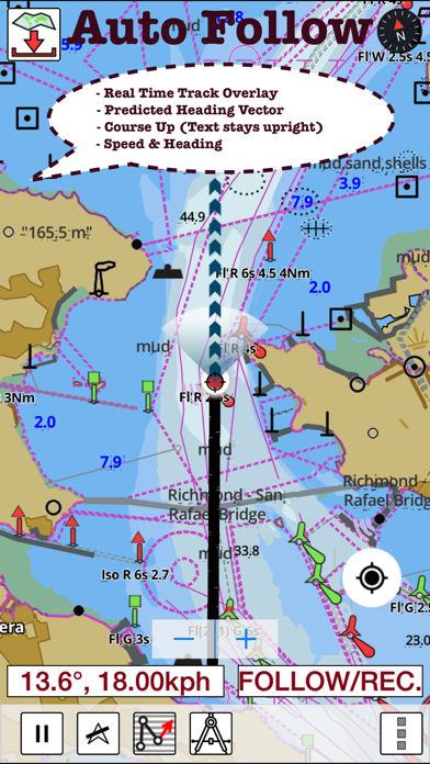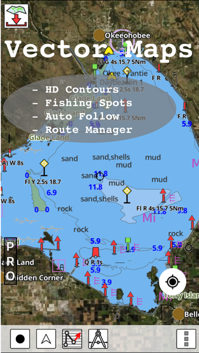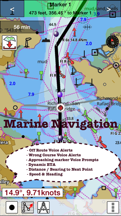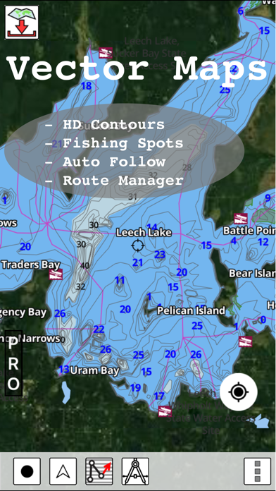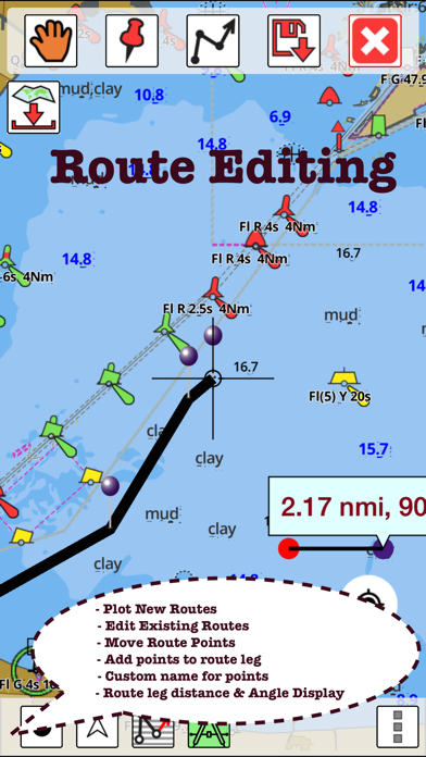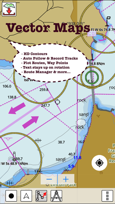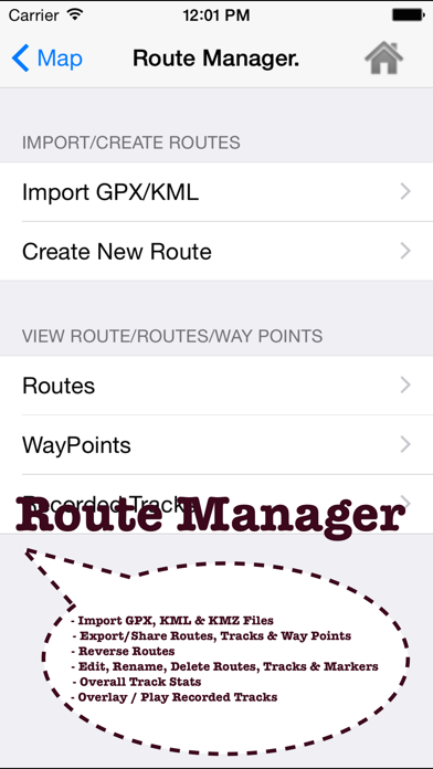
GPS Marine Charts App offers access to charts covering Canada (derived from CHS data). Only marine GPS app to have route assistance with Voice Prompts for marine navigation. It has route manager to create new boating routes or import existing GPX/KML routes. It supports Nautical Charts course up orientation. Please visit http://gpsnauticalcharts.com/main/ca-nautical-charts-by-folio.html for complete list. If you don't find the chart for Canada , please contact us at support at gpsnauticalcharts.com. (Includes coverage for Trent Severn Waterway incl. lake Simcoe etc.) * Voice Prompts for marine navigation (requires GPS ) -prompts when approaching a boating route marker -Continous distance and ETA updates -Alerts when sailing/boating off route -Alerts when boating in wrong direction *Route Editing/Creation -Create routes from scratch -Edit existing GPX/KML routes. -Add custom description to any route point. -Drop markers along route. * Offline charts derived from CHS data. -Visually draw area to download -Textual search -Catalog (By state, region and coast guard district) -Charts reprojected for WGS84 datum *Seamless chart quilting of marine charts *Distance Bearing tool *Create custom way points - Using GPS -Select point on map -Manually enter latitude & longitude coordinates *POI layer for marine charts - Overlay POIs - POI list derived from the equivalent ENC and contains all categories including Buoy, Light, Harbour facility, Obstr. *Search POIs/Way points *Pan/Zoom/My Location * Record Marine GPS tracks * View tracks overlay * Live track animation * Track analytics/stats * Export GPX tracks. -Export to SDCard -Share GPX trakcs with friends. * Auto Follow Mode (Course up) -Continuously updates boat's location on chart - Adjustable update frequency Sample Nautical Charts (please visit http://www.gpsnauticalcharts.com/ for complete list) Pacific Coast - Vancouver Island East & West - Haida Gwaii Great lakes Canada and St. Lawrence river Trent-Severn Waterway BALSAM LAKE BALSAM LAKE TO/À BOLSOVER (LOCK/ÉCLUSE) BOLSOVER (LOCK/ÉCLUSE) TO/AU LAKE SIMCOE CAMERON LAKE CHEMONG LAKE ÉCLUSES DE HEALY FALLS LOCKS TO/AU RICE LAKE LAKE COUCHICHING - LAKE SIMCOE TO/À COUCHICHING LOCK/L'ÉCLUSE DE COUCHICHING LAKEFIELD LAKEFIELD LOCK/ÉCLUSE 26 LAKEFIELD TO/À BURLEIGH FALLS LAKE SCUGOG LAKE SIMCOE PETERBOROUGH TO/À LAKEFIELD PIGEON LAKE (NORTH PORTION/PARTIE NORD) PIGEON LAKE (SOUTH PORTION/PARTIE SUD) RICE LAKE RICE LAKE TO/À PETERBOROUGH STONY LAKE STURGEON LAKE Lake Erie \ Lac Erie Lake Huron\Lac Huron Lake Huron\Lac Huron (Southern Portion\Partie sud) Lake Ontario\Lac Ontario Lake Ontario\Lac Ontario, Western Portion\Partie ouest Lake St. Francis Lake Superior\Lac Superieur Vancouver Harbour, Central Portion\Partie Centrale Vancouver Harbour, Eastern Portion\Partie Est Vancouver Harbour, Western Portion\Partie Ouest Vancouver Island\Ile de Vancouver, Juan de Fuca Strait to\a Queen Charlotte Strait of Georgia BARRIE BATAWA LOCK / ÉCLUSE 4 BEAVERTON HARBOUR BENSFORT BRIDGE TO/À PETERBOROUGH BIG CHUTE BIG CHUTE MARINE RAILWAYS BER ROULANT BIG CHUTE TO / À PORT SEVERN BOBCAYGEON - LOCK/ÉCLUSE 32 BOBCAYGEON - LOCK/ÉCLUSE 32 BOBGAYGEON - LOCK/ÉCLUSE 32 BUCKHORN BUCKHORN - LOCK/ÉCLUSE 31 BUCKHORN TO/À GANNON NARROWS AND/ET HARRINGTON NARROWS BURLEIGH FALLS BURLEIGH FALLS LOCK/ÉCLUSE 28 BURLEIGH FALLS TO/À BUCKHORN CAMPBELLFORD LOCK / ÉCLUSE 13 COOK'S BAY AND/ET HOLLAND RIVER COUCHICHING LOCK / ÉCLUSE 42 COUCHICHING LOCK TO BIG CHUTE ÉCLUSE COUCHICHING À BIG CHUTE CROWE BAY LOCK / ÉCLUSE 14 DOURO LOCK/ÉCLUSE 24 FENELON FALLS - LOCK/ÉCLUSE 34 FRANKFORD LOCK / ÉCLUSE 6 GANNON NARROWS TO/À BOBCAYGEON GLEN MILLER LOCK / ÉCLUSE GLEN ROSS LOCK PLEASE NOTE: Continued use of GPS running in the background can dramatically decrease battery life.