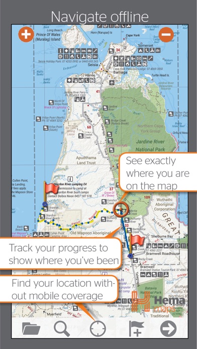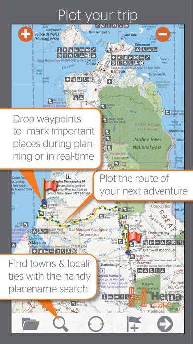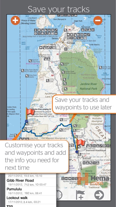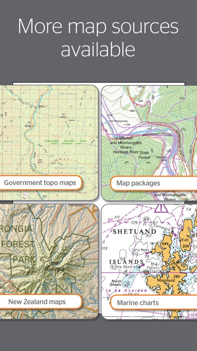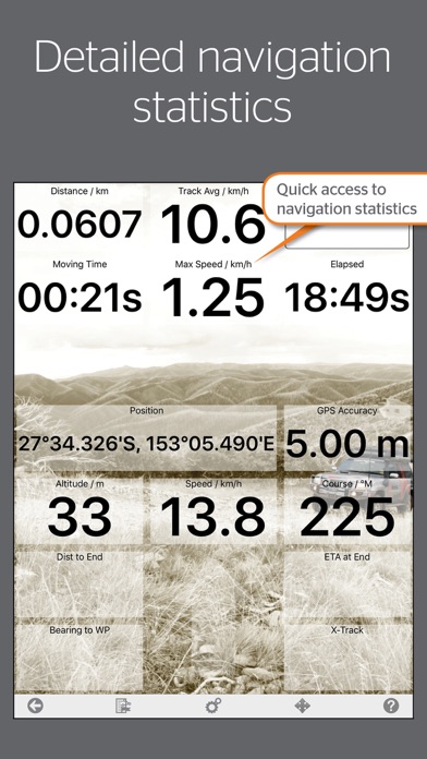
Best value Hema App. The one-time cost includes all Hema 4WD maps, without any recurring subscriptions. Use offline mapping and your device’s in-built GPS receiver to see where you are on detailed Hema maps, which feature roads, 4WD tracks, topographic information and POIs to guide your travels off the beaten track. NAVIGATE OFFLINE Find your location Real-time GPS tracking* Australia-wide map coverage Simple zooming PLOT YOUR TRIP Drop waypoints Plan routes Placename search SAVE & RECORD YOUR TRACKS Record your trips Create tracklogs Save tracks with information Share tracklogs & waypoints ACCESS HEMA'S PREMIUM MAP COLLECTION The app comes preloaded with a massive library of Hema touring and 4WD maps that covers all of Australia: Base Maps: Australia 1:250K TOPO Hema Explorer Map at 1:150,000 - 1:10M Goldfields-Esperance - Cape Arid NP Goldfields-Esperance - Cape Le Grand NP Cape York - The CREB Track Cape York - Lakefield NP Cape York - The Tip Goldfields-Esperance - Fitzgerald River NP Flinders - Flinders Ranges Mainmap Flinders - Mount Remarkable NP Flinders - Flinders Ranges NP Flinders - Vulkathunha Gammon Ranges NP Fraser Island - Central Station Fraser Island - Mid Fraser Fraser Island - Rainbow Beach Great Desert Tracks - North Central Great Desert Tracks - North East Great Desert Tracks - North West Great Desert Tracks - South Central Great Desert Tracks - South East Great Desert Tracks - South West Goldfields-Esperance and Southern Coast of WA Goldfields-Esperance Region High Country Victoria East High Country Victoria West Top End - Kakadu National Park Outback NSW - Kinchega NP Sth West Corner - Margaret River Wine Region Mid West Western Australia Mid West WA - Francois Peron NP Mid West WA - Kalbarri NP Mid West WA - Kennedy Range NP Mid West WA - Mount Augustus NP Outback NSW - Mungo NP Outback NSW - Mutawintji NP Outback New South Wales Outback Queensland Outback QLD - Bladensburg NP Outback QLD - Carnarvon Gorge Outback QLD - Currawinya NP Outback QLD - Diamantina NP Outback QLD - Idalia NP Outback QLD - Mt Moffat Outback QLD - Salvator Rosa and Ka Ka Mundi Pilbara Pilbara - Cape Range NP Pilbara - Karijini NP Pilbara - Millstream Chichester NP Pilbara - Rudall River Karlamilyi NP Simpson Desert 1:1,100,000 Simpson Desert 1:500,00 South West Corner - 200k South West Western Australia Goldfields-Esperance - Stirling Ranges NP Goldfields-Esperance - Stokes NP Outback NSW - Sturt NP The Kimberley The Kimberley - Dampier Peninsula The Kimberley - Purnululu NP The Kimberley - Wyndham-Kununurra The Red Centre Top End and Gulf - Boodjamulla NP Top End and Gulf - Darwin Region Top End and Gulf - Gregory NP Top End and Gulf - Keep River NP Top End and Gulf - Nhulunbuy DOWNLOAD ADDITIONAL MAP SOURCES Access a wide range of additional map sources which are available for purchase via the Memory-Map Digital Map Shop. USE ON WINDOWS PC or MAC Use the same maps and overlays on your desktop/laptop to plan your route and review tracklogs. (Maps sold separately). *You do not need a SIM Card installed or cellular coverage to utilise the GPS tracking functions on iPad for the app, though a WiFi+Cellular iPad is necessary to discover and track your location. A WiFi-only iPad does not contain the in-built GPS that a WiFi+Cellular iPad does, however external Bluetooth GPS receivers can be purchased for use with a WiFi-only iPad.