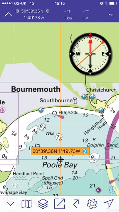
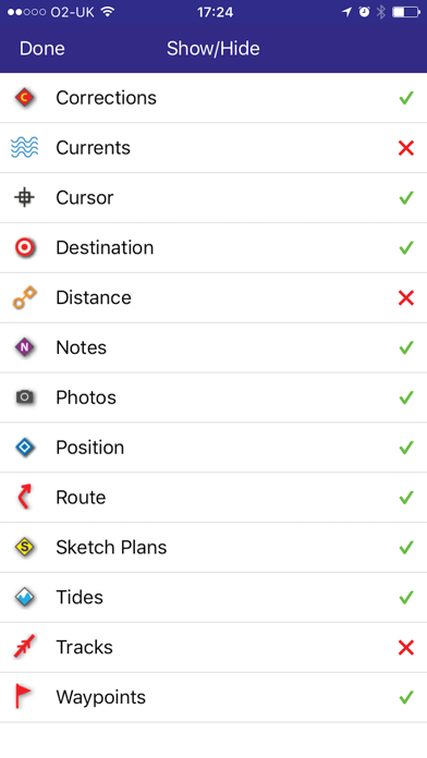
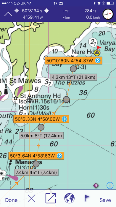
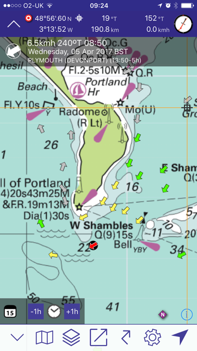
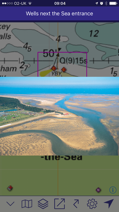
Imray's marine chart plotter for sailors, divers, canoeists, fishermen and anyone involved with making way at sea. Nautical charts by Imray and other publishers Easy to use for passage planning and route creation Keep up to date with new chart subscriptions for the latest data Plan your routes and share tracks and waypoints with your crew or friends Based on the award-winning Marine Imray Charts app Technical support for this app is available to subscribers. Email [email protected] FEATURES - Award winning raster charts from Imray and other Hydrographic Offices - Auto-renewable 12-month subscription includes quarterly updates with new chart editions, notes and corrections. - Waypoints - Routes: distances, targets, bearings - Position and destination - Course to steer, speed and bearing - Magnetic compass - Distances, bearings from any point to any point - Electronic bearing line - GPS and instruments - Tides with full functionality from Tides Planner app - AIS and NMEA functionality from Boat Instruments app - Aerial photographs (subject to coverage) and harbour plans - Tracks that you can share with friends Download Chart Sets from the Chart Store in the app. Warning: Continued use of WiFi and of GPS running in the background can dramatically decrease battery life. COVERAGE (CHART SETS) Tap on the i icon in the Chart Store in the free app to see more detail of coverage areas. Imray Charts free app: English Channel passage charts. Imray ID10 North Sea Imray ID20 English Channel England and France. Imray ID30 West coast England, Wales, west coast Scotland, Ireland. Imray ID40 Atlantic France, Iberia and Atlantic Islands. Imray ID50 Western Mediterranean. Gibraltar to Sicily. Imray ID60 Central Mediterranean. Adriatic and Ionian Seas. Imray ID70 Eastern Mediterranean and Aegean Seas. Imray ID80 Netherlands Imray ID100 Eastern Caribbean. Virgin Islands to Grenada and Barbados. Also chart sets derived from official Hydrographic Office charts of Germany, France and the Netherlands. Tides - inherits permissions (beyond one day predictions) from the Tides Planner app if installed on the same device. LANGUAGES English, Dutch, French, German, Italian and Spanish SUBSCRIPTIONS TO CHART SETS Before taking out a subscription to Imray Navigator chart sets, please check that your device meets the minimum operating system requirements (Apple iPhone and iPad running iOS8 and higher). A subscription to a Chart Set covers a 12 month period from the date of purchase. During this period, you will receive 3 further quarterly updates, which will include new chart editions, notes and corrections/updates for that area where available from the publishers. Your subscription will automatically renew unless auto-renew is turned off in your Account Settings at least 24-hours before the end of the current period. Your account will be charged for renewal within 24 hours prior to the end of the current subscription period. The cost of the renewal is the same as your current yearÕs subscription. You can manage your subscription and you may switch off auto-renewal by going to your Account Settings in iTunes after purchase. PRICES AND PAYMENTS The price of a year's subscription is indicated in the Chart Store section of the app. The price of your Imray Navigator subscription will be charged to your iTunes account at confirmation of purchase. Any unused portion of a free trial period, if applicable, will be forfeited when the user purchases a subscription to that Chart Set. Manage your subscription in iTunes after purchase. Privacy policy https://www.imray.com/privacy Terms and Conditions of use https://www.imray.com/terms ABOUT US Imray is the leading publisher of nautical charts, books and apps. Our charts, designed and published in England, feature popular, carefully edited and award-winning cartography. Twitter @imray_charts Facebook @imraynautical