Great Depths

Great Depths

By Walk About Apps

  • Category: Navigation
  • Release Date: 2013-05-16
  • Current Version: 4.0
  • Adult Rating: 4+
  • File Size: 19.33 MB
  • Developer: Walk About Apps
  • Compatibility: Android, iOS 8.0
Score: 4.16667
4.16667
From 12 Ratings

Description

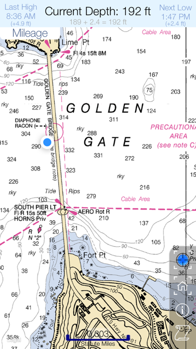
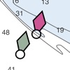
Turn your iOS device into a digital depth finder. Great Depths offers coverage of the entire US coast, the Great Lakes, Lake Champlain and more... Know exactly where you are on the water and cruise to your port of call directly and safely. Sail with Great Depths for iPhone and iPad. Great Depths offers digital depth readouts, live tide data and NOAA RNC nautical charts in 60 bargain-priced packages. Digital depth readouts are automatically adjusted based on current tide/lake level and are updated as you move or viewed anywhere with the touch of a finger. -- The handy mileage menu calculates distance between any two points instantly. -- Purchases are automatically synced across all your iOS devices and downloaded packages are stored locally on your devices so you don’t have to rely on cell service. -- Best of all, Great Depths is FREE and never has adds! You can download the app and preview the available charts packages without spending a dime. Chart coverage includes the entire coast of the contiguous USA, the Great Lakes, Lake Champlain, the Erie, Oswego and Champlain Canals, Lake Mead, Lake Oswego, Lake Pend Oreille, Lake Okeechobee, Lake Winnebago, Franklin D. Roosevelt Lake, Lake Cayuga, Lake Seneca Lakes, Wake Island and more....

Screenshots

Reviews

  • Map automatically switches 😤

    5
    By Lickmybuttholeplease
    The map always automatically loads to a picture map. It is very irritating and I would love to just keep the satellite map on while I browse the ocean depths. Is there any way to just keep the satellite map on without it automatically switching?
  • good but lacking

    4
    By TommyFisherman12
    Need to flag protected areas so this can be used for on water navigation 36° 33.650' N. lat. 121° 57.600' W. long.; 36° 33.650' N. lat. 121° 58.500' W. long.; 36° 33.100' N. lat. 121° 58.500' W. long.; 36° 33.100' N. lat. 121° 57.600' W. long.; and 36° 33.650' N. lat. 121° 57.600' W. long. Be able to enter coords like this so that it will show the boundaries of that protected fishing area
  • Great app!!

    5
    By Quinny75
    We were visiting Lake Champlain for the week and had a paper chart but our chart plotter didn't cover this area. Got this app while exploring the lake and it was a tremendous help when cruising along!
  • LookED good

    2
    By LaHoopster
    But on an iPad and 6+ the app locks up and will not function. Trying to expand to a point where you can actually READ the charts of Lake Champlain and the Hudson canal produce more lockup. App is nonfunctional for me and two emails to the support contact produced NO response-which was the largest disappointment. I doubt a refund is to be offered, but one is certainly in order!
  • Simply the best

    5
    By Dj Yun
    Great app with many great features, simple intuitive to use. Keep up the excellent work.
  • Owner/Opp

    4
    By RandyOnR3
    Of what I've used... it works great.. looking for nav. aids as direction and distance
  • Cool but the crash...

    4
    By ChristopherK78
    Very, very cool. Crashes are common and slow to load. Other than its actually quite awesome.
  • Great app

    5
    By Fish Sticks1
    Solid. The charts and digital depth readings are great. Perfect for cruising around Lake Champlain.
  • I use it all the time.

    5
    By elizabethbodunn
    Perfect for day trips on the bay. The tide predictions are really nice. A+ app.
  • App support is great

    4
    By Swelch1123
    I asked for a demo before I bought it and they responded in 2 days with free demos. Great customer support

keyboard_arrow_up