Flyskyhy

Flyskyhy

By Renevision

  • Category: Sports
  • Release Date: 2012-04-17
  • Current Version: 8.2.1
  • Adult Rating: 4+
  • File Size: 30.17 MB
  • Developer: Renevision
  • Compatibility: Android, iOS 12.0
Score: 4.47825
4.47825
From 69 Ratings

Description

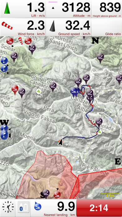
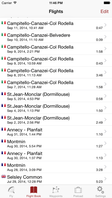
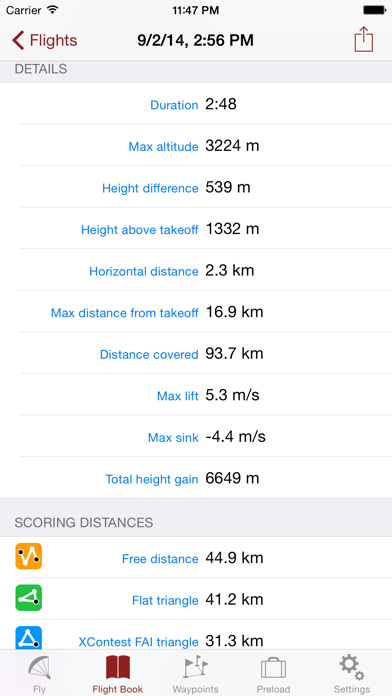
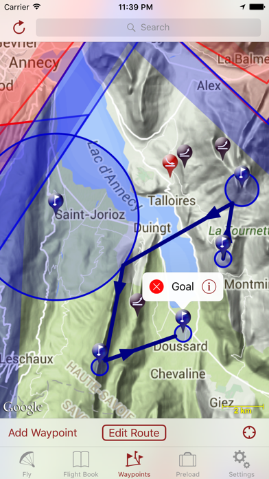
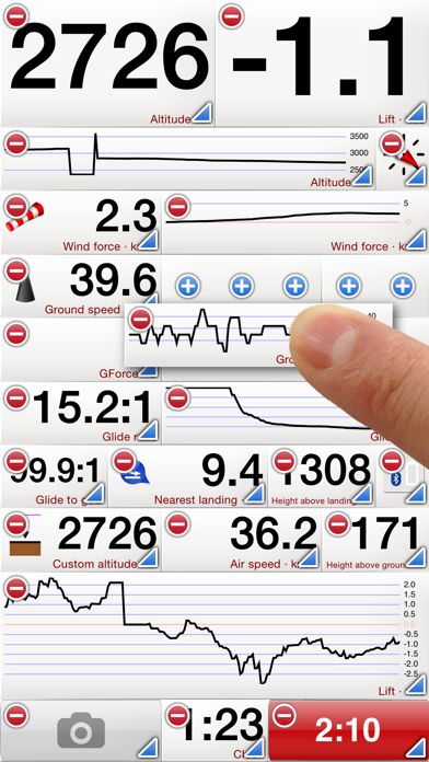
Flyskyhy forms your flight instrument during flight and shows all information you need for that. You get the normal data like altitude, climb rate, ground speed, and glide angle. But it also calculates and shows the current wind direction and strength, very important for your safety. A moving and rotating map shows your current flying position and flight trail. It indicates where you have gone up (in a thermal), and where you have had faster than normal decline. With that, you can easily find back that thermal that you lost. The map also shows the nearest known landing spots, and whether they are reachable by normal glide, given your current altitude and wind direction. Integration with Bluetooth varios SensBox, FlyNet, GoFly iPico, XC-Tracer, BlueFlyVario, or SkyDrop gives accurate altitude and lift information. That turns your iPhone into an full-fletched GPS-vario, including vario tones. The app makes a full log of your flight, that can be analyzed afterwards. Besides normal data like start and landing positions, duration of flight, and an altitude graph of the flight, Flyskyhy also calculates the scoring distances for you. So you can immediately see whether you have broken that FAI triangle record. Your live location is reported on livetrack24.com or loctome.com if you desire, so anybody can follow your flight while it is happening. If you are flying together with friends, then their location is shown on your map during your flight. So you never have to wonder anymore whether they are in front of or behind you. The flight display has multiple screens which are all fully configurable. You can move all elements to other spots, delete and add elements, and resize them. Through in-app purchases, the app also supports airspaces and waypoints. The app is optimised for paragliding and hang gliders, but can be used with all kinds of airsports. Main features during the flight; • Altitude, climb rate, ground speed, air speed, direction, glide angle and many more • Wind strength and direction • Moving map of the flying area • Spots where you have had lift, great for thermal coring • Shows whether you can still reach a landing spot with the current altitude and wind • Live tracking of your flight on livetrack24.com or loctome.com • Shows live location of your friends during flight After the flight: • Full logbook of all your flights • Basic flight data like start/landing, duration, height difference, distance flown, and many more • Calculation of 5-points, open triangle, and FAI triangle distances • Graph of altitude and climb rate • Signed IGC and KML log files of flights • Transfer the log to iTunes or send by email • Upload the flight directly to XContest, ParaglidingForum, DHV-XC, and other Leonardo servers • Open flight in Google Earth on the iPhone • Replay the flight and relive it! By purchasing the Waypoints Extension you get access to: • A fully zoomable and scrollable map with the waypoints and optimised route. The map also shows start and landing spots, as well as restricted airspaces (with the Airspace Extension) • Enter new waypoints, either on the map or by specifying the parameters • Full route support with start time, goal, entry/exit points, etc. • Many instruments to guide you along the route • Visible and audible indication when a waypoint has been reached • Complete waypoints organiser • Import and export of various waypoint file formats By purchasing the Airspace Extension you get access to: • Airspaces of 30 countries • Display of airspaces on the map with configurable colors and formats • Display of your vertical position w.r.t. airspaces • Visible and audible warnings when approaching and entering an airspace • Shows local airspaces by touching a spot on the map Note: a live internet connection is required for live tracking of your and your friends locations Note: continuous GPS and screen usage makes the battery drain faster than normal

Screenshots

Reviews

  • Paramotoring

    5
    By Ponderosa59
    Best app ever for paramotoring. Easily share your flight with other pilots. Pinpoint accuracy to check flight history. Flight replay.
  • Apple Watch support???

    5
    By Jay23E
    Any plans for Apple Watch support? That would be very useful for basic info like altitude ground speed etc. just a thought. Awesome app.
  • Amended: My ‘Go-to’ App for PPG and Pg

    5
    By Jim_VA
    I’ve now used this app for more than two years. I’ve logged both PG and PPG flights during that time with more than 200 hours para motor flights. Since my first review, I’ve had several exchanges with developer by email who was always very responsive. Kudos. The newly added Comments field (after flight editable) and other enhancements are greatly enhance this App’s use as useful logbook to record notes about each specific flight. The flight tracking function and ability to replay the flights seems very accurate. Found and linked to my BlueFlyvario easily.
  • Great app for XC Tracer & PG

    5
    By ChilliTrav
    I use this app for paragliding, Bluetooth paired with my XC Tracer Mini II GPS (instead of internal iPhone sensors which aren’t as accurate), and it works splendidly! IMO, anyone who is expecting an app to turn their phone into a solid variometer is kidding themselves, and really not using this kind of app appropriately. Doing that is relying on internal phone sensors that simply aren’t meant to be used for a variometer. However, if one pairs their phone to a REAL variometer and uses this app as the display, it is GREAT! Customizable screens make personalized layout easy. Landscape layout means it fits on my flight deck nicely. Thermal display and auto-switching to thermalling display facilitate centering on the thermal core. The Telegram group chat for extra tips and help is super handy too. I really don’t have any complaints.
  • Not great

    2
    By m72422
    The only useful thing this app does is send data to livetrack24, and it only kind of does that. There is no feedback if someone messes up their livetrack24 login credentials in the app, it just doesn’t send data. We were fighting this all week at our event after recommending people use this app. Also when uploading flights to leonardo the data (glider type etc) doesn’t work correctly. Anything else this app could be good for requires buying “extensions” so to have full functionality this is a $40 app. I would love to have a moving map with airspace, roads, towns, waypoints and maybe even other pilots I am flying with. This app might do it but no way it’s worth $40 to find out.
  • Fantastic for paramotors too

    5
    By aranpura
    I looked at many different apps to use while paramotoring, and even considered the expensive (but nice) Garmin smartwatch options. FlySkyHy gives me everything I would want and more, in a highly customizable interface clearly designed by someone who flies. I particularly like the automatic flight logs and the ability to display altitude above sea level and above ground level at the same time. If I had any criticism, it's that the emphasis on function over form leaves it looking a tiny bit homemade. But I would trade an ornamental interface for an well-considered and functional one any day.
  • Good App

    5
    By ranetworkers
    I normally use the “thermal assistant” like back up from my vario, this last weekend I forgot my instrument and one of the back up batteries on home. I was able to close a dreamed FAI triangle and make a small 30 kms task the next day. I highly recommend this app, my only suggestion is: “Is possible have a “voice assistance” with a count down for the start, like 5 minutes, 1 minute, 30 seconds, 10,9,8…. and/or can choose any sound we want for the alarms like Start open or en every waypoint? Thanks 🙏
  • An exceptionally well built app

    5
    By FlyCodeRepeat
    This app perfectly replaces the need for a high end flight instrument for just a few dollars. And it makes sense, you already have the best computer/gps in your pocket. The thermal centering tool is excellent and has significantly helped me improve my thermaling abilities. I also love how it will switch between the glide screen and thermal screen automatically. The wind direction tool is also pretty accurate and has helped me determine the wind direction a number of times. Battery life is good on an iPhone 11 but I do recommend using an external battery for longer flights. You can also turn the screen off which will save battery. I even broke my vario and for a few months used the built in vario in the app. While slightly delayed compared to a dedicated vario, it still works very well. So well I’m fact, that my 3 longest flights were all accomplished using the built in vario. An awesome option as a back up vario, or for more casual pilots that don’t want to pay big money for a dedicated vario. Also, you can change the vario sound! As someone who uses a Bluetooth speaker to listen to music while flying, this is a hugely underrated feature. Finally I can pick a sound and volume level that blends perfectly with my music instead of a clashing beep beep. I could go on and on about the features, but overall the app is extremely well built, performs a variety of functions, and is incredibly stable. I was considering switching to android but I think I may have to stay in the iPhone ecosystem just for this app—it’s that good. Strongly recommend to anyone who’s a paragliding pilot with a flight deck.
  • App works great for sailplanes

    4
    By Airplanek8
    App has been great so far but could definitely use additional sailplane features like an estimate of needed altitude to reach target based on glide ratio and groundspeed. The maps could be a bit more clear resolution as well. I'd like the app icon to be updated to reflect glider pilots as well :) Keep up the good work!
  • Only good for recording tracks

    2
    By BarryThePirate
    None of the numerical instruments give useable numbers: - lift is insanely optimistic, often showing 2m/s+ when my other instrument and senses tells me more realistically that I’m going down. - glide ratio is very pessimistic - wind speed calculations always believe I have a massive tailwind when on glide because of speed bar. Calculations are even further off if your phone is not aligned to your direction of flight. - if more than 100km from my house, height agl is equal to my altitude msl, indicating that the app is not loading ground height data. This is even when I have very good reception. As a result the only useful things the app does for me are: - show a map (with airspace and waypoints) - record my track - report my position to livetrack24. It does not feel like the full fledged instrument I would expect from a phone app.

keyboard_arrow_up