iHikeGPS : Classic Topo Maps

iHikeGPS : Classic Topo Maps

By James Associates Inc.

  • Category: Navigation
  • Release Date: 2010-02-12
  • Current Version: 9.4.5
  • Adult Rating: 4+
  • File Size: 11.74 MB
  • Developer: James Associates Inc.
  • Compatibility: Android, iOS 12.0
Score: 4.37736
4.37736
From 53 Ratings

Description

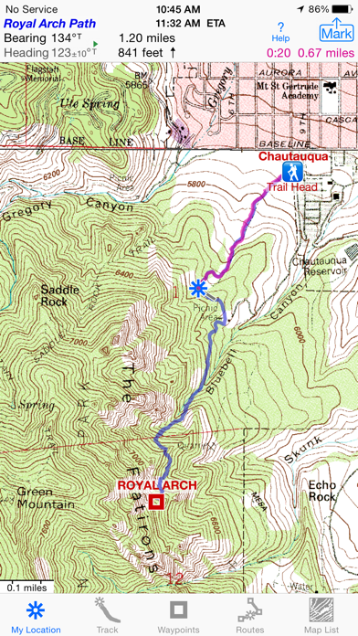
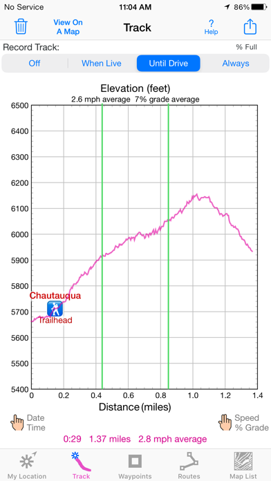
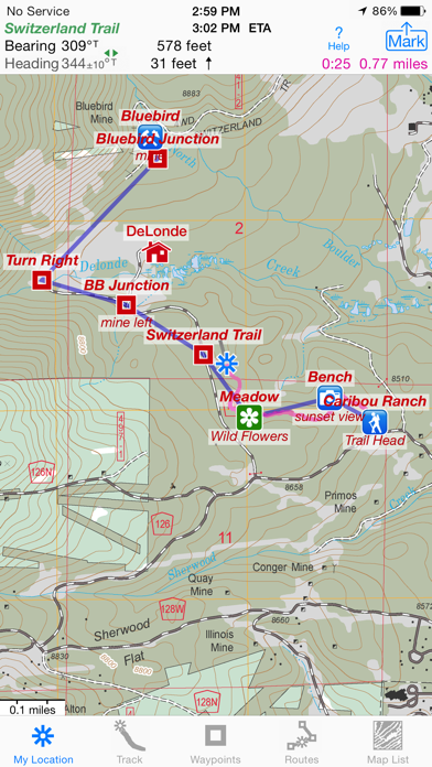
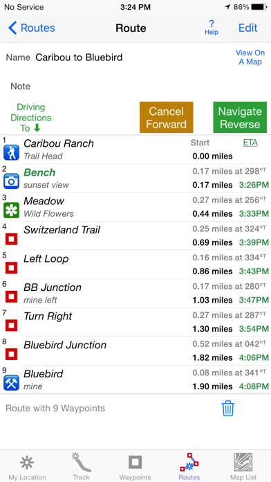
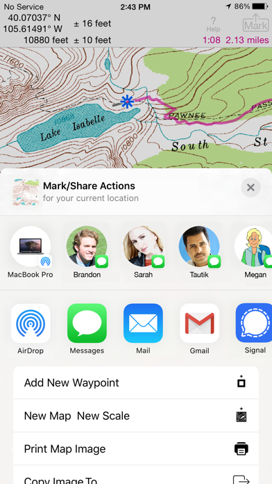
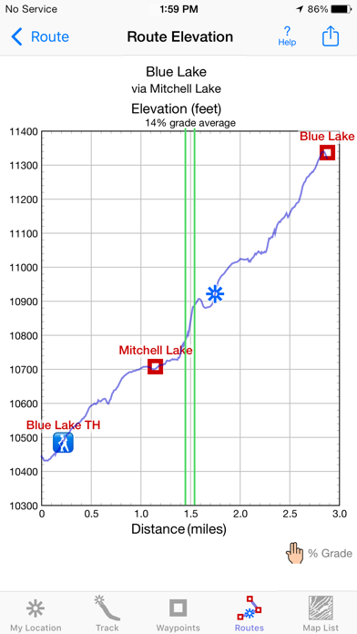
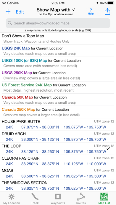
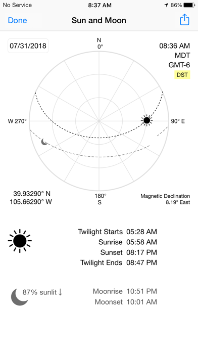
Unleash the navigation potential of your iPhone or iPad with iHikeGPS! Turn your device into a high-performance GPS receiver, equipped with USGS, US Forest Service & Canadian topo maps. These Classic topo map quads often have valuable back country details that vector maps in other hiking apps don't show. Even in remote areas with no cell signal, iHikeGPS ensures you always know where you've been, where you are, and where you’re going. Experience the ultimate hiking companion, offering unparalleled track recording, route navigation & accurate Estimated Time of Arrival. iHikeGPS eliminates sign-ups, ads, subscriptions & in-app purchases, making it more affordable, hassle-free & respectful of your privacy. Discover the limitless possibilities of iHikeGPS while hiking, backpacking, biking, canoeing, geocaching, camping, sightseeing, 4WD exploring & hunting. Recommended as the top choice in “Essential Gear for Safe Hiking”, it's a must-have for outdoor enthusiasts. TRACKS, WAYPOINTS & ROUTES Record tracks as you hike, even in the background. View them on the map with a Trip Timer & Odometer. View elevation graphs of your tracks & routes. Show date, time, average speed and % grade. Measure the area inside a closed path. Mark waypoints precisely using topo or satellite maps, place names or addresses, geotagged photos or by projecting from a known point. Set a quick GoTo waypoint or a full route & see the heading, direction, distance, elevation change and Estimated Time of Arrival at your destination & intermediate waypoints along the trail. Create customized routes using waypoints, recorded tracks, or imported GPX, KML or TCX files. Advanced route editing. Send waypoint, route, track & map list files via AirDrop, eMail, Messages or iCloud Drive. View the sun & moon position, rise times, & set times for any date & place on earth. Send data to other apps such as Google Earth. TOPO MAPS AT NO EXTRA COST USA: Newest US Forest Service FSTopo 24K maps USGS 24K maps for all 50 states, Guam, Puerto Rico & the US Virgin Islands USGS 250K & 100K (63K for Alaska) maps for all states Canada: National Resources Canada 50K maps for all areas south of 50° latitude. For Alberta, British Columbia & Newfoundland, coverage extends to 54° latitude. Download using WiFi or cell service. Our maps are optimized to download faster & use less storage memory. Store up to 2200 maps to use in the wilderness without cell service. These beautiful richly detailed offline topographic map images stitch together for seamless coverage across map boundaries. Print & Share map images overlaid with waypoints, routes & tracks. Measure distance and direction between any 2 points. USE THE UNITS YOU PREFER Miles, Nautical miles or Km Feet or Meters Degrees, Degrees/Minutes, Degrees/Minutes/Seconds, UTM or USNG-MGRS °True or °Magnetic HOW TOS Comprehensive Help in the App Online Manual on iHikeGPS.com Email developer: [email protected] WHAT OTHERS SAY “I am VERY impressed!!!…It pretty much blows…, my previous fave GPS app, out of the water. Your track recording features, fast map downloads, and well thought out interface make it a real winner. It's very sophisticated software, and makes my iPhone just about as good as $600 Garmin… Actually better, in a lot of ways”-John in OR “Perfect for anyone camping, fishing & hiking, it'll provide great detail when you need it the most…for anyone who takes the great outdoors seriously”-David's review “thank you for developing IHIKE GPS…what a great product it is. I am impressed!…I use it hiking, biking, skiing & Jeeping”-Ammon in CO DEVICE REQUIREMENTS Use iHikeGPS on any iOS device even if you don't have a cellular data plan for it. iPhones & WiFi+cellular iPads support full navigation. WiFi-only iPads & iPod touch can view maps, but require an iOS-compatible external GPS receiver to show your location & record tracks. Join thousands of satisfied users who rely on iHikeGPS for their outdoor adventures!

Screenshots

Reviews

  • Confusing maps approach

    3
    By bb1769
    I downloaded this app based on favorable reviews. But so far it’s confusing. I’m a GIS professional and programmer so don’t think it’s just me. I downloaded a few 24K maps near me, then downloaded a few 100K maps surrounding those. Then I wanted to download some 24K maps within the areas of the 100K maps. So far I have not found a way to do so. Tried various taps and buttons but no luck. Maybe once you’ve downloaded a coarser scale map you cannot also download a finer scale map of the same area. I also can’t zoom out very far— pinching out only zooms out to a pretty local scale, so can’t see the context. EDIT: I see the developer wrote a rather snippy reply to my review. Guess I must have touched a nerve. I'll admit that I did not thoroughly read all the Help material before posting the review, though I did consult it more than the average user would have. I mentioned that I hadn't found a way to download a 24K map in an area where I had already downloaded a 100K map. That was based on the instructions to tap the page in order to download a map. Subsequently I did find how to download the 24K map after you have another map for the same area. But it's not obvious: click the "Map List" tab along the bottom, then click the "+" icon at top left, then tap "Satellite Map Locator", then zoom/pan to where you want the new map, then tap the "+" in upper right, then tap the "Add USA 24K USGS Map". Whew. The approach for maps here is completely different (not "a little different") from any of the other GIS/GPS apps I've used (which is quite a few). It's not because it's raster vs. vector based, since other GIS/GPS apps also use raster/tile based maps. I guess my bottom line is that if you're willing to put in some time to learn the quirky interface, the app can be useful for limited areas of travel. I still wonder about zooming out, though--I can't zoom out beyond a radius of about 3 miles with the 24K map view enabled, or around 20 miles with the 250K map view.
  • Battery Saver - on Trail or close to Home

    5
    By Felge12345
    My location is determined by automatically receiving multiple satellite signals. Therefore iHikeGPS works completely with my iphone while being in (or not being in) Airplane Mode. I have used it 10+ years. My Hiking days are less each year (age 81); iHikeGPS is my most used GPS App. Now it is easily used to help find my car in a large Parking Lot! Thank you to the authors for creating and updating a wonderful and useful App, without a subscription fee.
  • Best hiking app

    5
    By 14584277267
    Have used a variety of GPS apps. This is best for US and Canada users because it’s easy to import/export GPX and other common formats, it uses the very familiar USGS/USFS topo maps at all scales (1/24K to 1/250K), and once the needed maps are downloaded it needs no mobile data connection. It also has no subscription fees and no strange proprietary maps. It would be nice if it also took geolocated PDFs, but so far so good.
  • Don’t leave home without it

    5
    By RedRoadster500
    This is one of my first apps. I was just beginning to understand the ropes of navigating with a hand held gps. They were fascinating to me. Then I discovered IHikeGPS. Works offline, download and store USGS and USFS maps, create waypoints, no hassles with subscriptions or purchases. One inexpensive payment and actual product support from the author. There is a learning curve. It’s not steep. It is important to read the instructions and not assume to much. Works on the ground, in a plane or car. This app shows me where in at and where I’m going.
  • Lost

    4
    By Reebry
    I can’t get it to track. I want an app to leave a trail; breadcrumbs. Even on the blank page it left a straight line. Downloaded a map and nothing. Press the track button and it stays on off.
  • A little fix?

    5
    By Boris Sidis
    It’s a great app. I like how as you scroll it moves from one contiguous map to another. How hard would it be for you to change the map title to reflect the new quad it’s on? Thanks.
  • Great app

    5
    By mcman56
    This app allows preloading maps so you can be well prepared for no cell phone service. The app has helped me get un-lost multiple times. It is also easy to use.
  • Great app.

    5
    By Kkowallis
    Have been using the app for several years and it works and has been a great resource in off road and backcountry. I would love to see two additions to the app. 1. Be able to show on apple CarPlay and 2. The ability to move in and out from high resolution maps to 100k by just zooming with finger motions instead of having to change maps.
  • Works great for my needs

    5
    By Just-a-person(&)-
    I didn’t want a social/sharing app. I just wanted to make a gps track and see a topo without needing any signal while hiking. I can download all the maps I need when I’m home on wifi.
  • Waypoints

    5
    By Presenurfect
    I like everything about it except I would like to be able to create waypoints using the elevation plot. Great to get this feature.

keyboard_arrow_up