TrailSmart: Great Trails

TrailSmart: Great Trails

By Eugene Mallay

  • Category: Travel
  • Release Date: 2017-03-10
  • Current Version: 3.70
  • Adult Rating: 4+
  • File Size: 82.36 MB
  • Developer: Eugene Mallay
  • Compatibility: Android, iOS 14.1
Score: 4.76
4.76
From 75 Ratings

Description

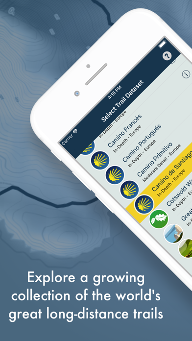
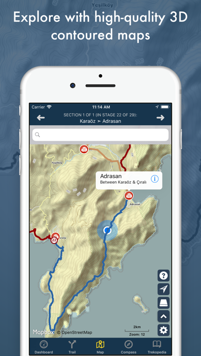
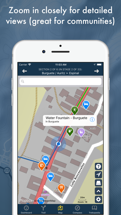
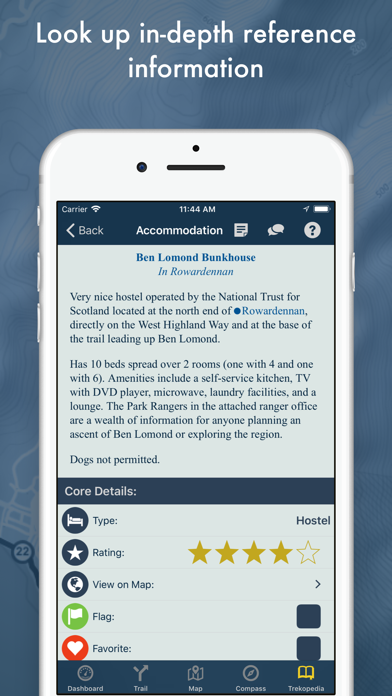
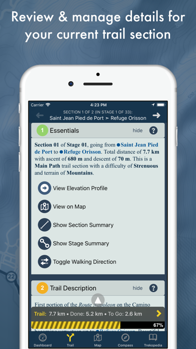
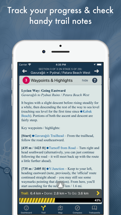
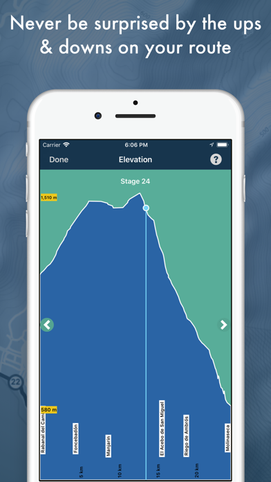
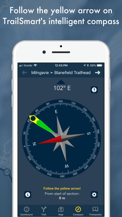
TrailSmart: Great Trails of the World is a comprehensive, incredibly handy mobile app providing in-depth coverage of some of our favourite long-distance trails. Use it on its own or as a complement to a printed guidebook. Once downloaded, no Internet connection is required. *** TrailSmart is fully-functional with all trail content included. In-app purchases are available for the optional offline maps; everything else is already included! No advertising and no hidden costs. *** Highlights of TrailSmart include: - An in-depth reference 'Trekopedia' (communities, accommodations, attractions, services, points of interest, etc.) - Highly customizable routes - Interactive maps (optionally including detailed offline maps) - Directions and section-by-section guide, which can be reversed to support walking either direction - Elevation profile charts - Dynamic trip stats for your current section, stage, and route - Toggle between metric / imperial - An intelligent compass that shows the right direction based on your current location and chosen route (just follow the yellow arrow!) - Add your own notes (reservation numbers, for ex), including geo-located notes directly on the map - Export / create backups of your own content and import it on other devices or share with friends - And much more! We're covering a growing collection of trails. Our current coverage includes: - Camino de Santiago (including the Francés, Primitivo, Portugués, Sanabrés, Norte, and Finisterre) - Cotswold Way (UK) - West Highland Way (UK) - Wainwright's Coast to Coast (UK) - Hadrian's Wall Path (UK) - Great Ocean Walk (Australia) - Lycian Way (Turkey) - Valleys, Trails & Churches of Cappadocia (Turkey) Got a request? Let us know! --- In-depth Reference Information --- TrailSmart's ‘Trekopedia’ is packed with extensive reference information on each trail. Everything can be searched and filtered, viewed on a map, notes can be added (anything from a simple reservation number to a copy-and-pasted blurb from a website), and more. --- Interactive Offline Maps --- Powerful, flexible maps that display your current location on your route along with pins showing all the locations included in the Trekopedia (just touch a pin to open its related Trekopedia entry). Filter and do searches. Detailed, high-quality offline maps are also available via in-app purchase, so you have full access to maps even without an Internet connection. When you do have an Internet connection, great online maps are also available. --- Intelligent Compass --- Just follow the yellow arrow! TrailSmart's intelligent compass points you in the right direction based on your current location and your selected route, and updates dynamically as you move. It takes into consideration all the twists and turns in your route and can even point you back in the right direction when off-route exploring towns. Never get lost again! --- Pre-Departure Planning & Preparation --- TrailSmart makes it easy to plan your route (including configuring the sections you want to follow), organize it into stages, and review distances and elevations (including a handy interactive Elevation Profile Chart). Comes pre-defined with popular routes (full and partial) plus you can create your own or edit ours. Review and rank hotels / guesthouses, flag locations of interest, add your own notes, and more. --- Up-To-Date Content --- TrailSmart's content is regularly updated and expanded based on the latest information available to us. You can check for content updates (including entirely new trail datasets) directly inside TrailSmart and download content whenever it is convenient for you (even on the trail), without having to connect to the App Store. Always be up-to-date! --- No Internet Connection Required --- All of TrailSmart's content is stored directly on your phone, including our detailed offline maps (once initially downloaded). No Internet connection is required!

Screenshots

Reviews

  • Indispensable app for Camino Primitivo

    5
    By happy return
    I have used the app constantly while walking the Camino Primitivo in May 2022. It has all the info you will need, starting from viewing the “Elevation Profile” for your next daily stages (that you can screenshot and save in photos or file for quick access) to the “Waypoints and Highlights” identifying landmarks (such as medieval ruins etc) and highlighting not-to miss needed stops for snacks/refreshments or water fountains, well tagged with miles-to-go so you can pace yourself and recharge, all the necessary data to make you better prepared for your Camino. My preferred tool is the Compass that will guide you to follow the yellow star and keep you on track without fail. The albergues listing and live links including their specific offerings (cost per night in dormitories or single rooms) come in very handy when you decide to call it a day and find your refuge for the night. I would be remiss if I didn’t mention the attention and quick support provided by the developer Eugene. Thanks for your detailed research and well designed app. David
  • Throw all your other apps away !

    5
    By kcat1962
    This App is all you need for your Camino Way trip or any other trail. We tried them all and this app and it’s support blew us away! The app is accurate and easy. It offers alternative routes, distances, compass, hotels and restaurants in the area, and much more. I cannot say enough about it. Truly a blessing as we traveled! Thank you TrailSmart and The Trekopedia Team for committing your time and knowledge into this app. Shout out and special thanks to Eugene!
  • Best Camino app!

    5
    By Robin FLNC
    I love this app! It’s genius in design! So detailed; everything you need is there. You can even download maps for use off-line. Developer Eugene Mallay is EXTREMELY helpful!! Buen Camino!
  • Must use for Lycian Way and other treks

    5
    By Lisa-C-M-1
    In short, TrailSmart is an incredible app with features that kept us 1. On the right trail 2. Safe on the trail and 3. Prepared mentally and physically for what was to come. The Trekopedia team provided real-time support when we had questions about the app content or when I had feedback to offer (email response within a couple of hours). I will be using TrailSmart for all my future long-distance hiking! My husband and I just finished walking the Lycian Way from Fethiye to Hisarcandir. This is an excellent but in many places rugged trail, and we could not have done it (or any of its sections) without TrailSmart. The features we used most often were: - trail map with GPS tracker - “magical yellow arrow” aka compass feature which always points to the next GPS point, helping us decide which way to turn when other indicators are unclear - elevation profile (with GPS capability displaying your current elevation) - water sources identified along the trail including status updates - details of lodging and campsites including location and amenities - communicating with the Trekopedia Team via email and the app “feedback” button was like having a Trail Angel whenever I connected to WiFi There is a learning curve to familiarize yourself with the app and how to access all of its features, which the “getting started” section in the app facilitates. For do-it-yourself trekkers, the cost of downloading the map (or free for all of the other features) is a worthy investment to access this compilation of professional and crowd-sourced wisdom. We are eternal fans of TrailSmart, and can’t wait for our next long-distance walk to use it again!
  • You need this one!!

    5
    By Team Happy Feet
    I got this recommended by a friend who has done many track “you need this one - forget the rest then you will be fine (and of course your boots)”. He was so right. Easy and so helpful when you are out there on your own. Thanks
  • TrailSmart Review

    5
    By ChiangXuXu
    I am walking the Camino Portuguese at present and so far I am happy with this app. I understand its a work in progress. I especially like the stages laid out. It helps me with planning my daily journey. Thank you.
  • Best Camino Francés app

    5
    By Dionysius123
    Hands down the best app out there if you’re new to the Camino. You don’t need the maps, this app lets you know every turn and albergue. I just did my first Camino and i have to say, i used this app every day and just threw away the book i had. The albergue list is perhaps the best feature. If you’re new to the Camino and are worried about how it will be, trust in yourself that you’ll be fine and use this app, everyone I met on the Camino switched to it once I showed them, and it’s free. You’ll see when you get out there what I mean
  • So helpful!

    5
    By EGW fron Richmond
    This app has been invaluable as I walk in March. I have missed the painted arrow a few times, and the tracker kept me on point. Helped me plan my stops each day because the stages are in the app. More albergues exist than in app, too. Highly recommend!
  • TrailSmart is a great Camino app, and more

    4
    By shimonunit
    I have been using Eugene's earlier app, TrekRight while walking the Camino Frances in 2016. We are now back walking the Camino Portuguese, and after emailing a question about a feature in the original app, and getting an almost immediate response, he shared about his newest app, TrailSmart, so I took a look. There is much to like in TrailSmart, which includes data for all of the Camino so, and much more. The hardest part for me was finding the tools I wanted and needed, and when I sent an email, he responded quickly, and clearly. Here's the thing that impressed me most: Support was really quick, he was very open to my questions as well as my enhancement requests, which is not something I expected, given that the app is essentially free, with an option for purchasing expanded offline maps with 17 levels of zoom, that were hugely useful since waymarkers are not always available. This saved us many times when we could easily have gotten lost. .
  • Camino Francés

    4
    By Camino Pilgrim
    I found TrailSmart invaluable while walking the Camino Francés, especially the interactive map. I introduced it to a British couple met along the Way who later said “you saved our life by telling us about TrailSmart”. That’s a bit overkill, but it helped them when they got off the beaten path. I especially like the offline capability of the interactive map as being from the States data can be expensive overseas. It is loaded with information. I’d give it 5 stars except that I found the user interface a bit cumbersome, but once you become familiar with the app and its capabilities, it is extremely useful. For trails supported, there is no need for a handheld Garmin or the likes. I hope they continue to add more trails.

keyboard_arrow_up